Mount Everest, the crown jewel of the Himalayas, stands as the world’s highest peak above sea level. Its towering presence has captivated explorers, mountaineers, and scientists for centuries. But just How High Is Everest, and what geological and climatic forces have shaped this colossal mountain?
The majestic Mount Everest massif in the Himalayas, Nepal, showcasing its immense scale and rugged terrain.
The Geological Story Behind Everest’s Height
The extraordinary height of Mount Everest is a direct result of powerful tectonic activity. The Himalayas, including Everest, were formed by the collision of the Indian-Australian Plate with the Eurasian Plate, a process that began approximately 40 to 50 million years ago. As the Indian-Australian Plate moved northward, it was forced under the Eurasian Plate in a process called subduction, causing the Earth’s crust to buckle and rise.
The Himalayas themselves began their ascent around 25 to 30 million years ago, with the Great Himalayas, the range housing Everest, taking their current form during the Pleistocene Epoch, which spanned from about 2,600,000 to 11,700 years ago. Mount Everest and its surrounding peaks are situated at a crucial junction, or knot, of this intense tectonic activity within the Great Himalayas. Remarkably, even today, Everest continues to grow, albeit minutely. Global positioning instruments placed on the mountain since the late 1990s indicate that Everest moves a few inches northeast and rises a fraction of an inch annually, a testament to the ongoing geological forces at play.
It’s interesting to note that the mountain’s Western name commemorates Sir George Everest, a British surveyor. Contrary to common mispronunciation as “Ever-est” or “Ev-rest,” the surname is correctly pronounced “EVE-rest.”
Everest’s geological composition is as fascinating as its formation. The mountain is built from multiple layers of rock, known as nappes, folded over themselves. The lower elevations are composed of metamorphic schists and gneisses, overlaid by igneous granites. Moving higher, sedimentary rocks of marine origin become prevalent – these are remnants from the ancient Tethys Sea floor, which disappeared after the Indian and Eurasian plates collided. A particularly striking feature is the Yellow Band, a limestone formation prominently visible just beneath the summit pyramid, adding a distinct geological marker to Everest’s imposing structure.
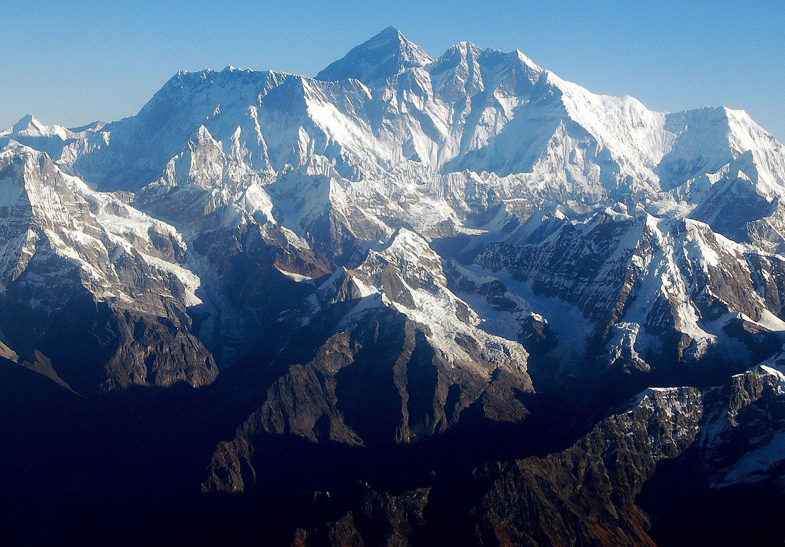
The summit of Everest is the convergence point of the barren Southeast, Northeast, and West ridges. Close by is the South Summit, a smaller prominence on the Southeast Ridge, reaching an elevation of 28,700 feet (8,748 meters). The northeastern face of Everest offers a direct view of the peak, rising dramatically about 12,000 feet (3,600 meters) above the Tibetan Plateau. To the north, Changtse peak rises to 24,803 feet (7,560 meters). Encircling Everest’s base to the west and south are Khumbutse (21,867 feet [6,665 meters]), Nuptse (25,791 feet [7,861 meters]), and Lhotse (27,940 feet [8,516 meters]), forming a formidable mountain landscape.
The perilous Khumbu Icefall at the base of Mount Everest, a challenging obstacle for climbers attempting to reach the summit.
Shaped like a three-sided pyramid, Everest’s faces and ridges define its structure. The North Face looms over Tibet, bordered by the North and West Ridges. Notable features on this face include the Great and Hornbein couloirs, and the North Col. The Southwest Face, rising above Nepal, is bounded by the West and Southeast Ridges, featuring the South Col and the infamous Khumbu Icefall – a chaotic maze of ice blocks that presents a significant challenge to climbers. The East Face, also known as the Kangshung Face, faces Tibet and is bordered by the Southeast and Northeast Ridges.
The very summit of Everest is capped with rock-hard snow, overlaid by a softer snow layer that varies in depth from about 5 to 20 feet (1.5 to 6 meters) throughout the year. The snow level peaks in September after the monsoon season and is lowest in May following depletion by strong winter winds. At such extreme altitudes, the atmospheric conditions are severe. The summit and upper slopes exist in an environment where breathable oxygen is only one-third of that at sea level. This oxygen scarcity, combined with powerful winds and frigid temperatures, prohibits any plant or animal life from surviving at Everest’s peak.
Drainage and Climate: Harsh Conditions at Extreme Altitude
The slopes of Everest, reaching down to its base, are heavily glaciated. Several glaciers descend from its flanks, including the Kangshung Glacier to the east, the East, Central, and West Rongbuk glaciers to the north and northwest, the Pumori Glacier to the northwest, and the Khumbu Glacier to the west and south. The Khumbu Glacier is fed by the Western Cwm, a valley of ice enclosed between Everest and the Lhotse-Nuptse Ridge. Glacial activity is the primary force relentlessly eroding Everest and the other towering Himalayan peaks, constantly reshaping the landscape.
The drainage system around Everest radiates outwards in southwest, north, and east directions. Meltwater from the Khumbu Glacier feeds into the Lobujya River in Nepal, which then becomes the Imja River, flowing south to join the Dudh Kosi River. In Tibet, the Rong River originates from the Pumori and Rongbuk glaciers, and the Kama River from the Kangshung Glacier. Both the Rong and Kama Rivers ultimately flow into the Arun River, which carves its path through the Himalayas into Nepal. These river valleys – Rong, Dudh Kosi, and Kama – serve as the northern, southern, and eastern access routes to the Everest summit, respectively, highlighting the interconnectedness of geography and human endeavors to conquer the mountain.
A frozen pond on the Khumbu Glacier near Mount Everest, illustrating the icy environment surrounding the world’s highest peak.
The climate of Everest is perpetually hostile. Even in July, the warmest month, the average daytime temperature at the summit is a frigid −2 °F (−19 °C). January, the coldest month, sees average summit temperatures plummet to −33 °F (−36 °C), with potential drops to an extreme −76 °F (−60 °C). Storms can arise with little warning, causing temperatures to fall precipitously. Everest’s extraordinary height places its peak within the lower reaches of the jet stream, exposing it to sustained winds exceeding 100 miles (160 km) per hour. Precipitation primarily falls as snow during the summer monsoon, from late May to mid-September. The combination of extreme cold, high winds, and altitude results in an exceptionally high risk of frostbite for anyone attempting to climb Everest, underscoring the formidable environmental challenges posed by the world’s highest mountain.