The world is a vast and diverse place, geographically speaking. We learn about continents from a young age, but the seemingly simple question of “how many continents are there?” actually has a surprisingly complex answer. It’s not just a matter of counting landmasses; it depends on how you define a continent in the first place.
Essentially, the number of continents varies based on different models, primarily stemming from geographical, historical, and cultural perspectives. Some systems recognize as few as four continents, while others identify up to seven. Let’s delve into the different ways we can count continents and explore why there isn’t a single, universally accepted answer.
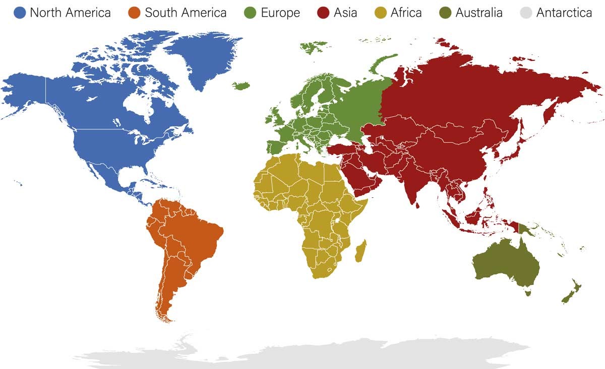 Map of the world with continents highlighted
The Four-Continent Model: A Geologically Focused View
One way to categorize continents is based purely on landmasses separated by oceans. This geological approach leads to the four-continent model. In this system, continents are defined as large, continuous land areas naturally divided by water bodies. According to this model, the continents are:
- Afro-Eurasia: Combining Africa, Asia, and Europe into a single, massive landmass.
- America: Uniting North and South America.
- Antarctica: The icy continent at the South Pole.
- Australia: Sometimes referred to as Oceania, this includes the Australian mainland and surrounding islands.
This model emphasizes the physical connections and separations of land, highlighting the vast scale of Afro-Eurasia as the largest single continental landmass.
The Five-Continent Model: Merging Americas and Excluding Antarctica
Another perspective simplifies the count to five continents. This model often merges the Americas into a single continent but excludes Antarctica due to its sparse population and unique characteristics. The five-continent model typically includes:
- Africa
- America: Combining North and South America.
- Asia
- Europe
- Oceania: Including Australia and the Pacific Islands.
This system is sometimes used in contexts where human population and cultural distinctions are considered more relevant than purely geological separation. Excluding Antarctica can be attributed to its lack of significant permanent human population and distinct geopolitical status.
The Six-Continent Model: A Hybrid Approach
The six-continent model attempts to strike a balance between geological landmass and cultural regions. It usually separates Eurasia into Europe and Asia but still combines North and South America. This model recognizes:
- Africa
- Antarctica
- Asia
- Australia (Oceania)
- Europe
- America (North and South America combined)
This model acknowledges the distinct cultural and historical identities of Europe and Asia while still treating the Americas as a single continental unit. It also brings Antarctica back into the count, recognizing it as a distinct landmass.
The Seven-Continent Model: The Most Widely Recognized System
By far the most commonly taught and recognized system, especially in English-speaking countries and within the realm of education, is the seven-continent model. This model distinguishes each of the major landmasses, including separating North and South America, and recognizing Antarctica as a continent. The seven continents, ordered from smallest to largest by land area, are:
- Oceania: 8,525,989 km² (3,291,903 sq mi)
- Europe: 10,180,000 km² (3,930,000 sq mi)
- Antarctica: 14,200,000 km² (5,500,000 sq mi)
- South America: 17,840,000 km² (6,890,000 sq mi)
- North America: 24,230,000 km² (9,360,000 sq mi)
- Africa: 30,365,000 km² (11,724,000 sq mi)
- Asia: 44,614,000 km² (17,226,000 sq mi)
Let’s explore each of these seven continents in more detail:
Oceania: The Island Continent
Oceania, the smallest continent, spans 8,525,989 square kilometers. Despite its size, it encompasses Australia, the world’s sixth-largest country by land area (7.688 million km²). With a population of approximately 45 million, Oceania is the second least populous continent, ahead of only Antarctica.
Oceania is geographically diverse, comprising Australasia, Melanesia, Micronesia, and Polynesia. It’s home to a collection of island nations and territories, showcasing a rich tapestry of cultures and environments.
Europe: A Continent of Peninsulas
Europe, covering 10,180,000 square kilometers, is the second smallest continent. Yet, it’s the third most populated, with around 745 million inhabitants. Europe is often described as a “peninsula of peninsulas” due to its complex coastline and numerous peninsular landmasses jutting out from the larger Eurasian landmass.
The exact number of countries in Europe is debated, depending on geographical and political definitions, but it generally includes around 50 nations. This includes transcontinental countries like Russia and Turkey, which have territory in both Europe and Asia.
Antarctica: The Frozen Continent
Antarctica, the fifth largest continent at 14,200,000 square kilometers, is unique as the coldest, driest, and windiest continent. It’s largely covered in ice and has a very sparse population, ranging from 1,000 to 5,000 people, primarily researchers stationed at scientific bases.
Antarctica is essentially a polar desert, playing a crucial role in global climate and ocean currents. Its unique environment and geopolitical status governed by international treaties set it apart from other continents.
South America: Home to the Andes and Amazon
South America, with a land area of 17,840,000 square kilometers, ranks as the fourth largest continent. Its population is estimated at over 434 million, making it the fifth most populous continent.
South America is renowned for its incredible biodiversity, the Andes Mountains, the Amazon rainforest, and vibrant cultures. It comprises 12 independent countries, with Brazil being the largest and fifth-biggest globally.
North America: From Arctic Tundra to Tropical Beaches
North America, the third-largest continent covering 24,230,000 square kilometers, has a population of approximately 600 million. Its diverse geography ranges from Arctic regions in the north to subtropical areas in the south, encompassing vast plains, mountain ranges, and coastlines.
North America is made up of Northern America, Central America, and the Caribbean. It includes 47 independent and dependent nations, including Canada and the USA, the second and third-largest countries in the world respectively.
Africa: The Cradle of Humanity
Africa, the second-largest continent at 30,365,000 square kilometers, is home to around 1.4 billion people. It represents approximately 20 percent of Earth’s total land area and is incredibly diverse in terms of cultures, landscapes, and ecosystems.
Africa is considered the cradle of humanity, with evidence of the earliest human ancestors found on the continent. It currently comprises 54 sovereign countries, with Algeria being the largest African nation.
Asia: The Largest and Most Populous Continent
Asia, the largest continent, dominates with a landmass of 44,614,000 square kilometers, nearly 30 percent of Earth’s land. It’s also the most populous, home to over 4.7 billion people – more than 60% of the world’s population.
Asia is incredibly diverse geographically and culturally, housing 51 countries, including four of the ten largest globally: China, India, Kazakhstan, and Russia. Defining Asia’s western boundary with Europe is complex, often using the Ural Mountains and Caspian Sea as a general dividing line.
What Defines a Continent? The Subjectivity of Continental Divisions
The very definition of a continent is not strictly scientific and is influenced by a mix of geology, geography, history, and cultural convention. Generally, a continent is considered a large, continuous landmass. However, the boundaries, particularly between Europe and Asia, are more a matter of historical and cultural agreement than clear physical separation.
The question of what constitutes a continent has led to the different models discussed. Geological factors like tectonic plates play a role, but the exact number and boundaries of continents remain somewhat subjective and open to interpretation. The movement of continents over geological time, as explained by plate tectonics and the concept of supercontinents like Pangaea, further highlights the dynamic nature of Earth’s landmasses.
The Americas: One, Two, or Three Continents?
The Americas present another interesting case in continental counting. While the seven-continent model clearly separates North and South America, some classifications combine them into a single “America” continent. Historically, and in some contexts like the Olympic rings symbolism, the Americas are treated as one.
Furthermore, Central America is sometimes considered a continent in its own right, or a sub-continent of North America, adding another layer of complexity to continental divisions.
Russia: A Transcontinental Nation
Russia’s geographical location straddling both Europe and Asia exemplifies the often-blurred lines of continental boundaries. While geographically, the majority of Russia lies in Asia, it is often considered a European nation culturally and politically, particularly due to its population density being concentrated in its European territories and its historical ties to Europe.
Using the Ural Mountains as a dividing line, most of Russia falls within Asia. However, major Russian cities, including Moscow, are located in the European part. This has led to Russia being considered a transcontinental country, bridging both Europe and Asia.
Read more about world geography and continental drift to deepen your understanding of our dynamic planet.