Mount Everest, the towering giant of the Himalayas, has captivated humanity for centuries. Its snow-capped summit, piercing the sky, represents the ultimate challenge for mountaineers and a subject of endless fascination for those on lower ground. One of the most frequently asked questions about this majestic peak is straightforward yet profound: How Tall Is Everest? This article delves into the details of Everest’s height, exploring not only the official measurement but also the geological forces that contribute to its ever-evolving stature and the extreme environment that defines the world’s highest point.
The Official Height of Mount Everest
Currently, the officially recognized height of Mount Everest is 8,848.86 meters (29,031.7 feet). This measurement was jointly announced in 2021 by Nepal and China, settling previous discrepancies and providing the most accurate figure to date. This precise measurement is the result of a collaborative effort, utilizing modern surveying techniques including Global Navigation Satellite Systems (GNSS), and traditional trigonometry. It represents the snow height at the summit, reflecting the most commonly understood and used figure for Everest’s elevation.
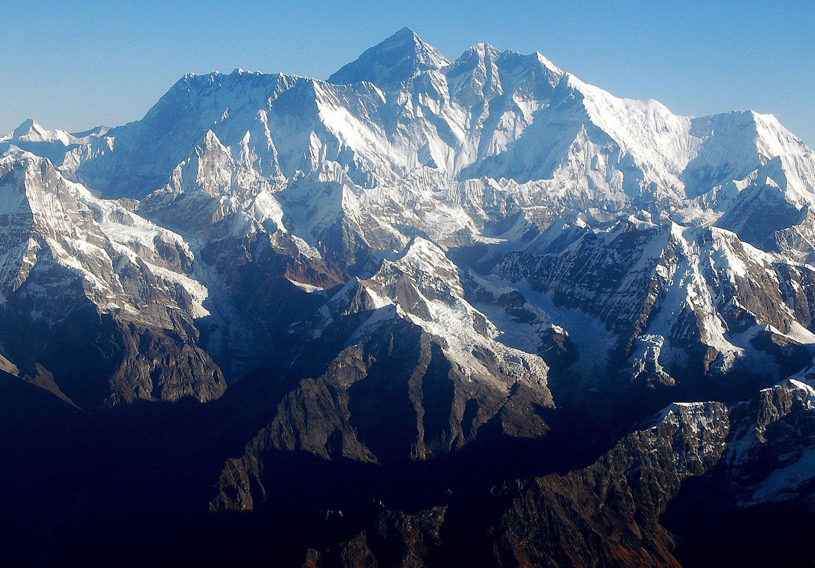
Alt text: Panoramic view of the Mount Everest massif in the Himalayas, Nepal, showcasing the scale of the mountain range.
The Ever-Changing Height of Everest: Tectonic Activity
It’s important to understand that the height of Everest isn’t static. The Himalayas are geologically young mountains, formed by the ongoing collision of the Indian-Australian and Eurasian tectonic plates. This immense geological pressure is what thrust the Himalayan ranges upwards in the first place, starting approximately 25 to 30 million years ago. Even today, this tectonic activity continues, causing Everest to not only shift slightly to the northeast but also to rise incrementally each year. Scientific measurements taken since the late 1990s, using global positioning instruments placed directly on Everest, indicate that the mountain rises by a fraction of an inch annually. This constant upward movement means that the height of Everest is perpetually, albeit minutely, changing.
Everest’s composition further illustrates its geological dynamism. The mountain is built from layers of rock folded over on themselves, known as nappes. Its lower sections are composed of metamorphic schists and gneisses, overlaid with igneous granites. Remarkably, higher elevations reveal sedimentary rocks of marine origin, remnants of the ancient Tethys Sea floor that existed before the Indian and Eurasian plates collided. A prominent feature, the Yellow Band, a limestone formation, is clearly visible just below the summit pyramid, serving as a geological marker on this colossal structure.
Measuring Everest: A History of Determination
The quest to measure Everest’s height has been a long and fascinating endeavor. Early estimations were made from afar, relying on trigonometry and observations from the plains of India. As surveying techniques advanced, so did the accuracy of measurements. The most recent official height, a result of meticulous modern methods, represents a culmination of centuries of effort to precisely define the altitude of the world’s highest peak. Each measurement campaign has faced unique challenges, from the extreme altitude and weather conditions to the logistical complexities of working in such a remote and high-altitude environment.
More Than Just Height: Everest’s Physical Features
While the question “how tall is Everest?” is central, understanding the mountain’s overall physical features provides a more complete picture of its grandeur. Everest is not just about its vertical height; its shape, structure, and surrounding environment are equally significant.
Pyramid Shape and Key Features
Everest is shaped like a three-sided pyramid, with distinct faces and ridges. The North Face, towering above Tibet, is defined by the North and West Ridges, and features notable geological formations like the Great and Hornbein couloirs. The Southwest Face, overlooking Nepal, is bordered by the West and Southeast Ridges and is infamous for the Khumbu Icefall, a treacherous labyrinth of ice blocks that climbers must navigate. The East Face, also known as the Kangshung Face, rises above Tibet and is bounded by the Southeast and Northeast Ridges. The summit itself is not a sharp point but a snow-covered dome, with the snow depth fluctuating by 5–20 feet (1.5–6 meters) throughout the year, influenced by monsoon and winter winds. Just a short distance away from the true summit is the South Summit, a slightly lower peak on the Southeast Ridge.
Alt text: The Khumbu Icefall, a hazardous and dynamic glacier section at the base of Mount Everest, posing a significant challenge to climbers.
Summit Snow Cap and Extreme Conditions
The extreme altitude of Everest means the atmospheric conditions at the summit are incredibly harsh. The air contains only one-third of the breathable oxygen found at sea level, creating the “death zone” where human survival is severely challenged. Combined with this lack of oxygen, climbers face powerful winds exceeding 100 miles per hour and extremely low temperatures. Even in July, the warmest month, the average summit temperature is around −2 °F (−19 °C), plummeting to an average of −33 °F (−36 °C) in January, with potential lows reaching −76 °F (−60 °C). These conditions preclude any plant or animal life at the summit and upper slopes, making it a truly barren and hostile environment.
Everest’s Climate and Drainage
The climate of Everest is intrinsically linked to its height and location within the Himalayas. Glaciers dominate its slopes, extending down to the base of the mountain. Notable glaciers include the Kangshung Glacier to the east, the Rongbuk glaciers to the north, the Pumori Glacier to the northwest, and the Khumbu Glacier to the west and south. The Khumbu Glacier is fed by the Western Cwm, a valley of ice nestled between Everest and the Lhotse-Nuptse Ridge, highlighting the extensive glacial system surrounding Everest. These glaciers are the primary agents of erosion, constantly reshaping Everest and the surrounding Himalayan peaks.
Alt text: A glacial pond on the Khumbu Glacier near Mount Everest in the Himalayas, Nepal, illustrating the icy landscape.
The drainage patterns of Everest radiate outwards. Meltwater from the Khumbu Glacier feeds into the Lobujya River in Nepal, which becomes the Imja River and eventually joins the Dudh Kosi River. In Tibet, the Rong River and Kama River, sourced from the Rongbuk and Kangshung glaciers respectively, flow into the Arun River. These river valleys—Rong, Dudh Kosi, and Kama—serve as natural access routes to Everest’s summit from different directions. Precipitation on Everest primarily falls as snow during the summer monsoon season, further contributing to the glacial ice and the challenging conditions faced by climbers.
Conclusion
So, how tall is Everest? It stands at an officially recognized height of 8,848.86 meters (29,031.7 feet), a figure that represents the culmination of geological forces and centuries of measurement efforts. However, Everest is more than just a number. Its height is a dynamic measure, constantly being influenced by tectonic activity. Furthermore, understanding Everest’s height requires appreciating its entire physical context – its pyramid shape, glacial environment, and extreme climate. It is this combination of factors that makes Mount Everest not only the world’s highest peak but also a truly awe-inspiring and formidable natural wonder.